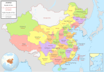
檔案:ROC PRC comparison eng.jpg
外觀
ROC_PRC_comparison_eng.jpg (770 × 600 像素,檔案大細:239 KB ,MIME類型:image/jpeg)
檔案歷史
按到日期/時間去眵吖許時間有過嗰檔案。
| 日期/時間 | 縮圖 | 尺寸 | 用戶 | 說明 | |
|---|---|---|---|---|---|
| 眼前 | 2015年1月18日 (禮拜天) 19:48 |  | 770 × 600(239 KB) | Wwbread | Part of Bhutan and Russia was Rep. China. It has been marked in this map but not painted white. Also marked Nanking and Peking by two bigger stars. |
| 2006年12月16日 (禮拜六) 14:03 |  | 770 × 600(316 KB) | Electionworld | {{ew|en|Pryaltonian}} == Legend details == * Black dotted lines are political boundaries drawn by the ROC. The formal names of these political entities are in black text. * Red solid lines are political boundaries drawn by the [[P |
檔案使用
全域文件用途
以下其他 wiki 使用了這個檔案:
- en.wikipedia.org 嗰使用狀況
- Talk:Chinese Soviet Republic
- Talk:Sino-Indian War
- Talk:Chinese constellations
- Talk:Black-faced spoonbill
- User:Pryaltonian
- Talk:Yixian Formation
- Talk:Shanxia
- Talk:Stegosaurides
- Talk:Tianchisaurus
- Talk:Heishansaurus
- Talk:Parama China kingdom
- Talk:Pingxing Pass
- Talk:Eleutherococcus senticosus
- Talk:List of Chinese star names
- Template:WikiProject China
- Talk:Chinese paddlefish
- File talk:ROC PRC comparison eng.jpg
- Template talk:WikiProject China
- Talk:Qingdao
- File talk:Zhengzhou location.png
- Talk:Wu (state)
- Wikipedia talk:WikiProject China/Cartography
- Talk:Snakehead (gang)
- Talk:Nothotsuga
- Talk:Morina nepalensis
- User talk:Nlu/archive34
- Talk:Qabiao language
- Talk:Nectocaris
- Talk:Daurian starling
- Talk:Reed parrotbill
- Talk:Chinese penduline tit
- Talk:Chinese thrush
- Talk:Zhejiangosaurus
- Talk:Yunnan box turtle
- Talk:Philippen's striped turtle
- Talk:Chinese false-eyed turtle
- Talk:Daurian ground squirrel
- Talk:Mutianyu
- Talk:Wuji County
- Talk:Aristolochia thwaitesii
- Talk:Chinese star maps
- Talk:Hamamelis mollis
- Talk:Jiufotang Formation
- Talk:North Linkor Road
- Talk:Beijing–Datong Expressway
- Talk:Ailurarctos
- Talk:Wan Chai Cargo Handling Basin
- Talk:Platostoma palustre
- Talk:China National Highway 324
- Template:WikiProject China/sandbox
檢視此檔案的更多全域使用狀況。


