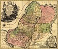
文檔:1759 map Holy Land and 12 Tribes.jpg

預覽嗰尺寸:715 × 599 像素。 其他分辨率:286 × 240 像素 | 573 × 480 像素 | 917 × 768 像素 | 1,222 × 1,024 像素 | 2,000 × 1,676 像素。
原始文件 (2,000 × 1,676 像素,檔案大細:1.74 MB ,MIME類型:image/jpeg)
檔案歷史
按到日期/時間去眵吖許時間有過嗰檔案。
| 日期/時間 | 縮圖 | 尺寸 | 用戶 | 說明 | |
|---|---|---|---|---|---|
| 眼前 | 2005年9月12日 (禮拜一) 10:43 |  | 2,000 × 1,676(1.74 MB) | Humus sapiens~commonswiki | 1759 map: Terra Sancta sive Palæstina exhibens no folum Regna vetera Iuda et Israel in fuas XII Tribus diftincta... Source: Library of Congress historical maps Category:Historical maps of the Middle East Category:Israel |
檔案使用
冇頁面連結到箇隻檔案。
全域文件用途
以下其他 wiki 使用了這個檔案:
- ace.wikipedia.org 嗰使用狀況
- af.wikipedia.org 嗰使用狀況
- anp.wikipedia.org 嗰使用狀況
- ar.wikipedia.org 嗰使用狀況
- ast.wikipedia.org 嗰使用狀況
- az.wikipedia.org 嗰使用狀況
- ba.wikipedia.org 嗰使用狀況
- be.wikipedia.org 嗰使用狀況
- bg.wikipedia.org 嗰使用狀況
- bn.wikipedia.org 嗰使用狀況
- ca.wikipedia.org 嗰使用狀況
- crh.wikipedia.org 嗰使用狀況
- cs.wikipedia.org 嗰使用狀況
- cv.wikipedia.org 嗰使用狀況
- da.wikipedia.org 嗰使用狀況
- de.wikipedia.org 嗰使用狀況
- de.wikisource.org 嗰使用狀況
- diq.wikipedia.org 嗰使用狀況
- el.wikipedia.org 嗰使用狀況
- en.wikipedia.org 嗰使用狀況
- en.wikiversity.org 嗰使用狀況
- eo.wikipedia.org 嗰使用狀況
- es.wikipedia.org 嗰使用狀況
檢視此檔案的更多全域使用狀況。

