
文檔:18 century Qing China.png
預覽嗰尺寸:616 × 599 像素。 其他分辨率:247 × 240 像素 | 494 × 480 像素 | 790 × 768 像素 | 1,053 × 1,024 像素 | 1,820 × 1,770 像素。
原始文件 (1,820 × 1,770 像素,檔案大細:4.79 MB ,MIME類型:image/png)
摘要
| 簡話 |
[] |
| 日期 | |
| 來源 | |
| 作者 | User:Soewinhan |
| 其他版本 |
[]
 |


授權
| 本圖像是中央情報局僱員的職務作品。作為美國聯邦政府的作品,本圖像或媒體屬於公有領域。
|

|
原始上傳日誌
Transferred from en.wikipedia to Commons by Logan using CommonsHelper.
The original description page was here. All following user names refer to en.wikipedia.
- 2011-01-09 07:39 Wengier 1820×1770× (3289864 bytes) slightly resize
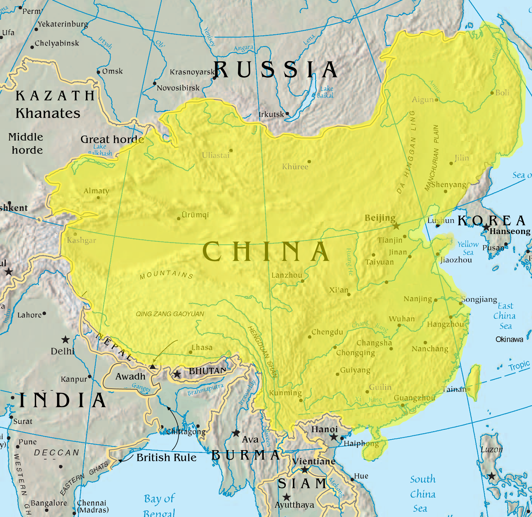
- 2011-01-09 01:55 Soewinhan 1850×2087× (5311396 bytes) {{Information | description = Map of Qing Dynasty prior to [[Sino-Burmese War (1765-1769)]] | source = Originally from CIA, taken [http://commons.wikimedia.org/wiki/File:Asia-map.png from commons] | date = 1-8-2011 | author
檔案歷史
按到日期/時間去眵吖許時間有過嗰檔案。
| 日期/時間 | 縮圖 | 尺寸 | 用戶 | 說明 | |
|---|---|---|---|---|---|
| 眼前 | 2019年1月7日 (禮拜一) 17:30 | | 1,820 × 1,770(4.79 MB) | Anchuhu | edit |
| 2011年5月3日 (禮拜二) 02:26 |  | 1,820 × 1,770(3.14 MB) | File Upload Bot (Magnus Manske) | {{BotMoveToCommons|en.wikipedia|year={{subst:CURRENTYEAR}}|month={{subst:CURRENTMONTHNAME}}|day={{subst:CURRENTDAY}}}} {{Information |Description={{en|Map of Qing Dynasty China in 1765<br/> en:Category:Qing Dynasty}} |Source=Transferred from [http |
檔案使用
冇頁面連結到箇隻檔案。
全域文件用途
以下其他 wiki 使用了這個檔案:
- ar.wikipedia.org 嗰使用狀況
- azb.wikipedia.org 嗰使用狀況
- be.wikipedia.org 嗰使用狀況
- de.wikipedia.org 嗰使用狀況
- en.wikipedia.org 嗰使用狀況
- eu.wikipedia.org 嗰使用狀況
- hak.wikipedia.org 嗰使用狀況
- hi.wikipedia.org 嗰使用狀況
- no.wikipedia.org 嗰使用狀況
- ru.wikipedia.org 嗰使用狀況
- sr.wikipedia.org 嗰使用狀況
- szy.wikipedia.org 嗰使用狀況
- tg.wikipedia.org 嗰使用狀況
- th.wikipedia.org 嗰使用狀況
- tl.wikipedia.org 嗰使用狀況
- zh-min-nan.wikipedia.org 嗰使用狀況
- zh.wikipedia.org 嗰使用狀況